L1-AR GNSS RTK Base+Rover RTK GPS Handheld Collector with Software & Visual Stakeout with Camera, Global Shutter with 2 MP, 2cm Accuracy, 120° Tilt Survey | Professional Support
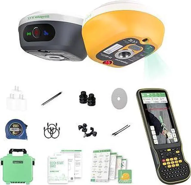
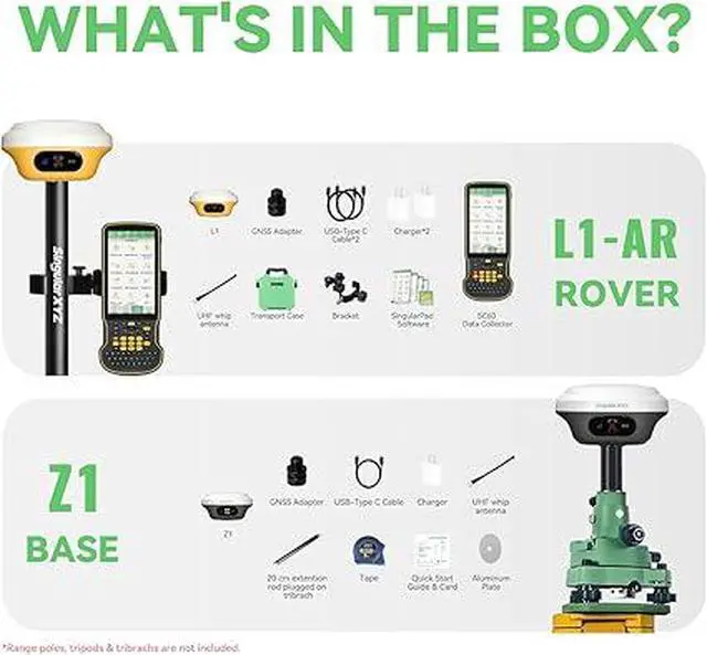
Included Components L1-AR GNSS Receiver, Transport Case*1, USB-Type C Cable*2, Super Charger*2, Whip Antenna*1, GNSS Adapter*1 SC60 Data Collector*1, Bracket*1, SingularPad Software*1 Quick Start Guide*1, Quick Start Card*1L1-AR GNSS Receiver, Transport Case*1, USB-Type C Cable*2, Super Charger*2, Whip Antenna*1, GNSS Adapter*1 SC60 Data Collector*1, Bracket*1, SingularPad Software*1 QuickStart Guide*1, Quick Start Card*1
Audio Output Mode Digital
Battery Life 12 Hours
+
+
Overview
Specs
Reviews
Any questions? Our AI beta will help you find out quickly.
Try me now
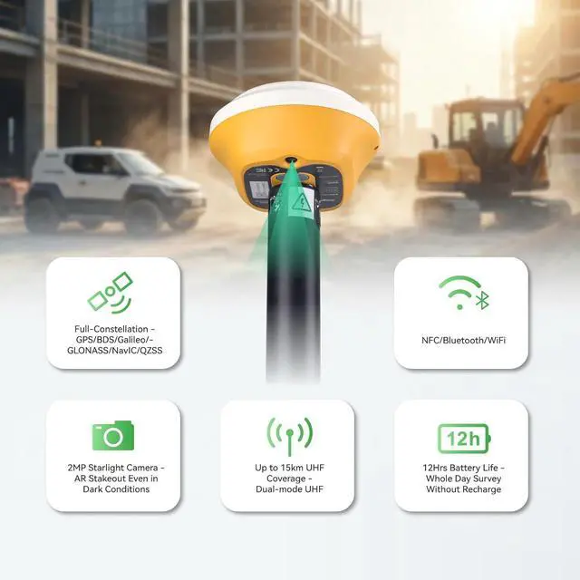
Centimeter RTK PerformanceL1-AR GNSS RTK support with1408-channel L1/L2 GNSS engine delivers 5-second initialization and centimeter accuracy under trees and urban canyons, supporting GPS/GLONASS/Galileo/BDS/QZSS/SBAS.
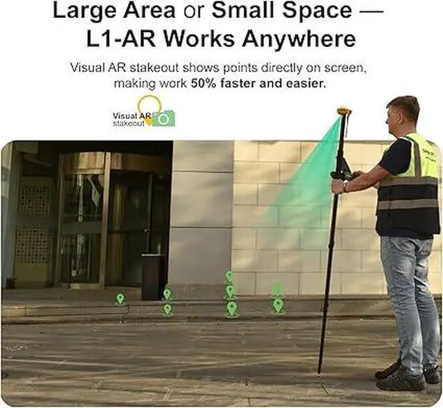
AR StakeoutL1-AR gps rtk enables AR stakeoutoverlaying virtual point guidance on the camera view for faster, intuitive field layout, and the handheld collector also can enables AR stakeout.
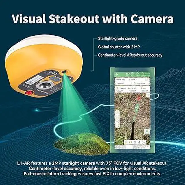
Global shutter with 2 MPL1-AR RTK features a 2MP starlight camera with 75° FOV for visual AR stakeoutCentimeter-level accuracy, reliable even in low-light conditions.Full-constellation tracking ensures fast FlX in complex environments.
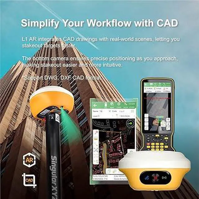
Simplify Your Workflow with CADL1 AR rtk gnss integrates CAD drawings with real-world scenes, letting youstakeout targets faster.The bottom camera ensures precise positioning as you approach.Making stakeout easier and more intuitive. Sapport DWG,DXF CAD.
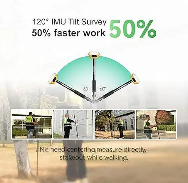
120° Tilt CompensationHigh-grade IMU supports ±60° tilt with auto-calibration, achieving 2cm accuracy at maximum tilt for faster, pole-free topographic surveys.
15km UHF RadioThe L1 gps surveying equipment built-in 2W UHF transceiver provides up to 15km rover-base range and supports RTCM/CMR, compatible with third-party bases and CORS/NTRIP workflows.
ABOUT USSingularXYZ focuses on high precision GNSS PNT (Positioning, Navigation & Timing) technology, extending its coverage to geospatial information, precision agriculture, machine control, robotics, telecom, IoT and etc., providing reliable, stable and professional products and service, committed to popularizing precision and intelligence into all aspects of people's lives, contributing to the construction of an informatized, intelligent and efficient world.
NoteU.S. users must apply for an FCC radio license for commercial use (e.g., surveying, construction) with the UHF function (450470 MHz). The device is FCC certified, and we can provide supporting info if needed. The rtk gps equipment does not include the pole.
Learn more about the Detailed Specifications
Additional Information
First Listed on Newegg
March 09, 2026
There are no reviews yet.
Do you own this product?
Warranty & Returns
Warranty, Returns, And Additional Information
Warranty
Please contact the Seller directly for warranty information. Warranty information may also be found on the Manufacturer's website.