Navionics+ NAUS007R U. S. East
Brand New
Product # 010-C1370-30
The Navionics+ NAUS007R is a microSD card that provides a detail-rich mapping of rivers, lakes, coastal waters, and more. With SonarChart™ 1? ( 0.5 meters) HD bathymetry maps, you advanced features like Dock-to-Dock Route Guidance Technology (depending on the Chartplotter model) that suggests you the path to follow through marina entrances, channels, inlets, and more, Plotter Sync enables wireless access to daily updates, and Live Mapping with the freshest chart data every time. Additionally, with multiple shading options, it is easy to locate the best fishing spots through shallow water navigation.
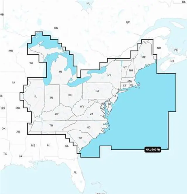
The NAUS007R microSD card covers the lakes, rivers, and coasts of Connecticut, Delaware, Illinois, Indiana, Kentucky, Maine, Maryland, Massachusetts, Michigan, New Hampshire, New Jersey, New York, North Carolina, Ohio, Pennsylvania, Rhode Island, South Carolina, Tennessee, Vermont, Virginia, and West Virginia.
Navionics+ NAUS007R Features:
U. S. East Marine Charts
Coastal Coverage
Dock-to-Dock Route Guidance Technology
SonarChart™ Live
Plotter Sync
- Plan on Mobile, go on Plotter
Integrated Garmin & Navionics® Data
Multiple Shading Options