Your Browsing History
- Free 30-day Returns
$2,150.00

Meet Your Seller
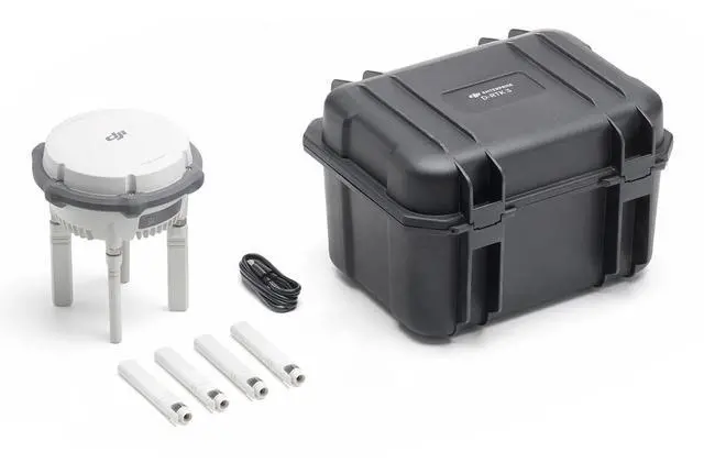


DJI D-RTK 3 High Precision GNSS Multifunctional Station
- UNMATCHED COMPATIBILITY - Seamlessly integrates with DJI Matrice series, DJI Inspire 3, DJI T60/T50/T40, and DJI FlyCart 30, enhancing your existing drone ecosystem with precision and reliability.
- SUPERIOR ACCURACY - Achieve centimeter-level precision with RTK accuracy (0.31" horizontal, 0.59" vertical), ideal for detailed surveys and mapping, ensuring reliable data collection every time.
- EXTENDED OPERATING TIME - Enjoy long-lasting performance with up to 10 hours of Rover Station operation, minimizing downtime and maximizing productivity in the field for uninterrupted workflows.
- RUGGED DURABILITY - Built to withstand harsh conditions, featuring an IP67 rating and 2m drop resistance, ensuring reliable operation in challenging environments and protecting your investment.
+
+
Overview
Specs
Reviews
Any questions? Our AI beta will help you find out quickly.
Try me now
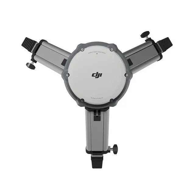
Where precision meets versatility, the DJI D-RTK 3 High Precision GNSS Multifunctional Station stands as a cutting-edge solution for advanced aerial surveying and drone operations. This innovative station integrates high-performance antennas and receiver modules, adept at tracking and resolving data from major global satellite navigation systems. It supports multiple data transmission links, making it an indispensable tool for drone operators seeking centimeter-level positioning accuracy. In Base Station Mode, the D-RTK 3 facilitates simultaneous operation of multiple drone models, including the new O4 Enterprise video transmission. Equipped with four external directional antennas, it enables video transmission up to 15 kilometers in base station broadcast mode, ensuring stable signals in all directions.
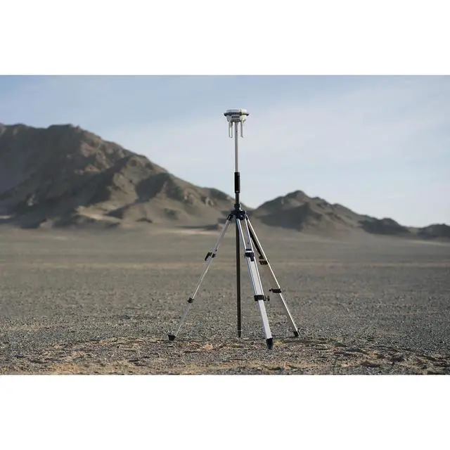
This setup allows multiple drones to connect effortlessly, accessing precise positioning without additional configuration. Switch to Relay Station Mode to overcome signal obstructions in challenging environments like urban areas or valleys. By positioning the D-RTK 3 at an elevated location, operators can enhance video transmission distance and extend the operational range of the Matrice 4 series up to 25 kilometers. The system supports obstruction sensing, allowing real-time calculations of signal quality and enabling operators to adjust drone positions for optimal communication. In Rover Station Mode, the D-RTK 3 excels in collecting control point coordinates, significantly enhancing UAV aerial survey accuracy.
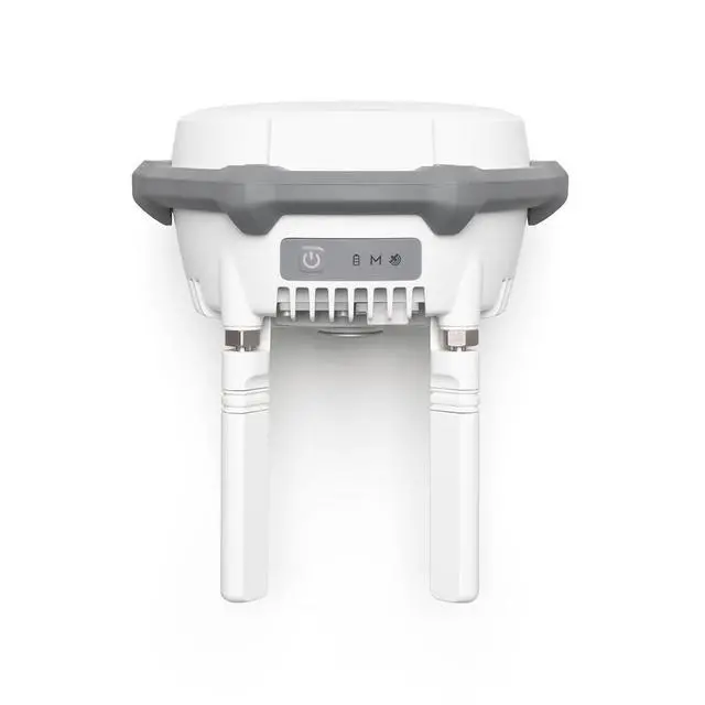
Its air dielectric antenna with a filtering design effectively tracks low-elevation satellites, maintaining antenna phase-center accuracy within millimeter levels. This ensures strong resistance to multipath interference, delivering high-precision positioning even in complex environments. The D-RTK 3's built-in receiver module can receive satellite data from five major satellite systems across nineteen frequency points, offering more accurate and stable positioning results compared to network RTK, especially under ionospheric effects. Utilizing DJI's proprietary Standalone Precise Point Positioning (PPP) solution, it provides satellite-based auto convergence, achieving decimeter-level positioning even in challenging network conditions. For network high-precision calibration, the D-RTK 3 can receive RTCM data, automatically obtaining coordinates and correcting positions through the network.
This allows for centimeter-level precision positioning outdoors without pre-measuring the setup point location. The new DJI Enterprise app enhances the D-RTK 3's capabilities, supporting Ground Control Point (GCP) setup and tilt compensation. This app, compatible with Android devices, allows for efficient high-precision surveying workflows when used with DJI drones supporting RTK. The built-in high-precision inertial measurement unit enables control point measurement without the need for a tripod, improving operational efficiency in complex environments. Moreover, the app includes a mainstream projection coordinate database for direct output of planar coordinates and is compatible with DJI Terra for efficient data processing.
Rover measurement results can be exported as control point files and imported into DJI Terra effortlessly, thanks to powerful algorithms that generate high-precision results. Additionally, the D-RTK 3 supports local PPK, recording raw satellite observations for seamless integration with DJI Terra version 4.4 or above, facilitating one-click local PPK calculations. The DJI D-RTK 3 High Precision GNSS Multifunctional Station is a comprehensive solution for professionals seeking unparalleled precision and efficiency in aerial surveying and drone operations.
This setup allows multiple drones to connect effortlessly, accessing precise positioning without additional configuration. Switch to Relay Station Mode to overcome signal obstructions in challenging environments like urban areas or valleys. By positioning the D-RTK 3 at an elevated location, operators can enhance video transmission distance and extend the operational range of the Matrice 4 series up to 25 kilometers. The system supports obstruction sensing, allowing real-time calculations of signal quality and enabling operators to adjust drone positions for optimal communication. In Rover Station Mode, the D-RTK 3 excels in collecting control point coordinates, significantly enhancing UAV aerial survey accuracy.
Its air dielectric antenna with a filtering design effectively tracks low-elevation satellites, maintaining antenna phase-center accuracy within millimeter levels. This ensures strong resistance to multipath interference, delivering high-precision positioning even in complex environments. The D-RTK 3's built-in receiver module can receive satellite data from five major satellite systems across nineteen frequency points, offering more accurate and stable positioning results compared to network RTK, especially under ionospheric effects. Utilizing DJI's proprietary Standalone Precise Point Positioning (PPP) solution, it provides satellite-based auto convergence, achieving decimeter-level positioning even in challenging network conditions. For network high-precision calibration, the D-RTK 3 can receive RTCM data, automatically obtaining coordinates and correcting positions through the network.
This allows for centimeter-level precision positioning outdoors without pre-measuring the setup point location. The new DJI Enterprise app enhances the D-RTK 3's capabilities, supporting Ground Control Point (GCP) setup and tilt compensation. This app, compatible with Android devices, allows for efficient high-precision surveying workflows when used with DJI drones supporting RTK. The built-in high-precision inertial measurement unit enables control point measurement without the need for a tripod, improving operational efficiency in complex environments. Moreover, the app includes a mainstream projection coordinate database for direct output of planar coordinates and is compatible with DJI Terra for efficient data processing.
Rover measurement results can be exported as control point files and imported into DJI Terra effortlessly, thanks to powerful algorithms that generate high-precision results. Additionally, the D-RTK 3 supports local PPK, recording raw satellite observations for seamless integration with DJI Terra version 4.4 or above, facilitating one-click local PPK calculations. The DJI D-RTK 3 High Precision GNSS Multifunctional Station is a comprehensive solution for professionals seeking unparalleled precision and efficiency in aerial surveying and drone operations.
Warranty & Returns
Warranty, Returns, And Additional Information
Warranty
- Please contact the Seller directly for warranty information. Warranty information may also be found on the Manufacturer's website.
- Read full details
- CONTACT
Return Policies
- Return for refund within: 30 days
- Return for replacement within: non-replaceable
- This item is covered by Adorama Return Policy
Manufacturer Contact Info
- For a directory of all our manufacturers, please click below.
- Manufacturers Directory
LOADING...