Your Browsing History

Make informed decisions with expert advice. Learn More

Any questions? Our AI beta will help you find out quickly.
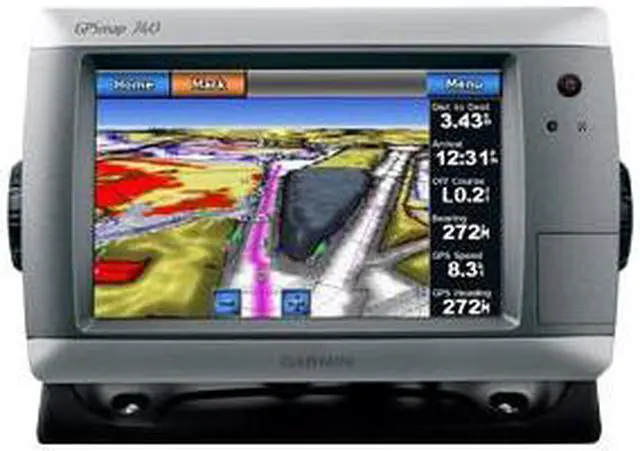
GPSMAP 740s is a stand-alone touchscreen chartplotter that brings a new level of functionality to your vessel. Featuring a brilliant 7" (17.78 cm) display, GPSMAP 740s puts all the information you need right at your fingertips. GPSMAP 740s is preloaded with U.S. coastal maps. In addition, GPSMAP 740s accepts radar input and offers full NMEA 2000 connectivity for greater convenience when adding extra sensors.
 Explore the SeasGPSMAP 740s contains preloaded map data for all U.S. coastal areas, including Alaska and Hawaii, plus Explorer Charts for the Bahamas. GPSMAP 740s also features an internal, high-sensitivity GPS receiver for superior satellite tracking and quicker acquisition times. And as an added benefit, GPSMAP 740s can receive graphical weather data for North America through the optional GXM 51 satellite receiver/antenna (sold separately).
 Take Control by TouchInput is easy with GPSMAP 740s. Whether you’re changing course or simply reviewing information in front of you, the intuitive touchscreen interface makes for simple operation. The device also offers flexible brightness levels for daytime readability along with low-light dimming during night use. And with a widescreen display that’s rugged and waterproof, it’s made to perform in any situation.
 Expand with RadarFeaturing a built-in radar port, GPSMAP 740s can be interfaced with Garmin’s line of affordable GMR marine radar systems (sold separately). Whether you’re adding radar now or in the future, you’ll enjoy the convenience of “plug-and-play installation” as well as the power, range and high-definition targeting of Garmin’s proven radar offerings. (Garmin Marine Network not supported.)
 Get Sonar with GPSMAP 740sGPSMAP 740s comes standard with a 1 kW-capable sonar transceiver. This powerful sonar can help you define fish targets and underwater structures as far down as 2,000 ft (609.6 m) when used with a 1 kW transducer. Depth capacity is dependent on water salinity, bottom type and other water conditions (with 1 kW transducer).
 Add Extras with BlueChart g2 VisionWith the optional BlueChart g2 Vision SD card (sold separately), you can add a whole new dimension of exceptional features to your chartplotter. MarinerEye view and FishEye view provide you a 3-D perspective of map information, both above and below the waterline. High-resolution satellite images and aerial photographs help you orient yourself in unfamiliar areas. Auto Guidance technology searches through all relevant charts to create a route you can actually follow — one that avoids obstacles, shallow water, buoys and other obstructions.