You’re seeing this ad based on the product’s relevance to your search query. If you are a seller and want to participate in this program click here to learn more.
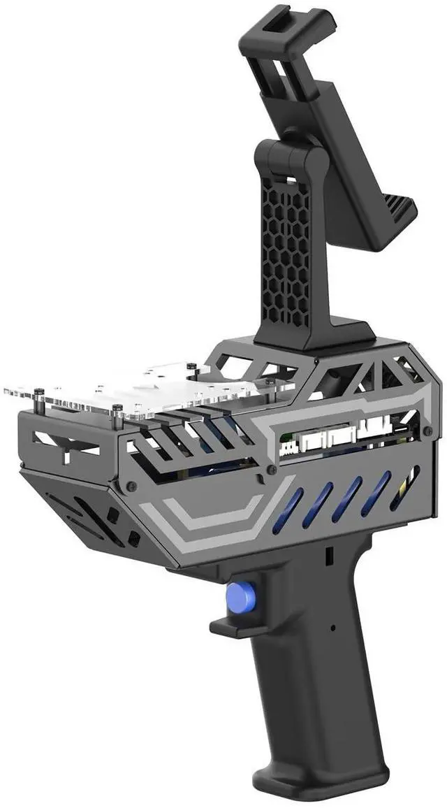
Handheld Scanning Lidar 3D Mapping Navigation Supports APP,ROS2,Linux, 6-Axis IMU MicroRos Communication with Multiple Radars (VM Software Not Support MAC) (without Lidar)
Limited time offer, ends 06/10 By Zhiyi Technology
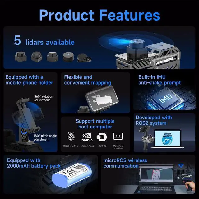
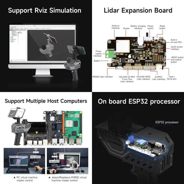
MicroROS Technology ApplicationUsing MicroROS virtual machine as PC main control, through WiFi-UDP wireless communication, without carrying a bulky computer, the radar data can be wirelessly transmitted to the PC virtual machine. (VM software not support MAC). Support RaspberryPi 5,Jetson Nano,RDK X5 as the main control,which can replace VM and provide complete information.
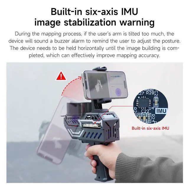
IMU positioning function and anti-shake reminderWith 6-axis IMU,it plays an important positioning function in map construction.At the same time, in order to prevent the lidar from tilting too much and causing distortion of map data,the research and development cleverly combined IMU to design an anti-shake reminder function.If PALMSLAM tilts in the map, there will be a buzzer alarm prompt (the alarm tilt angle is set after powering on).
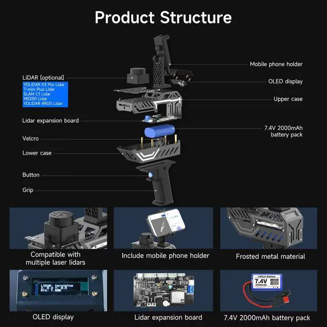
Perception enhancement is not limited to the plane5 lidar versions are available for selection X3PRO/TMINI PLUS/C1/MS200/4ROS,providing precise positioning,scanning frequency, measurement radius data and multi-dimensional information, enhancing perception, not limited to the plane, making the operation more accurate and reliable.if used by beginners, it is recommended to order the Tmini-Plus version.
Sponsored
You’re seeing this ad based on the product’s relevance to your search query. If you are a seller and want to participate in this program click here to learn more.
Any questions? Our AI beta will help you find out quickly.
Try me now
MicroROS Technology ApplicationUsing MicroROS virtual machine as PC main control, through WiFi-UDP wireless communication, without carrying a bulky computer, the radar data can be wirelessly transmitted to the PC virtual machine. (VM software not support MAC). Support RaspberryPi 5,Jetson Nano,RDK X5 as the main control,which can replace VM and provide complete information.
IMU positioning function and anti-shake reminderWith 6-axis IMU,it plays an important positioning function in map construction.At the same time, in order to prevent the lidar from tilting too much and causing distortion of map data,the research and development cleverly combined IMU to design an anti-shake reminder function.If PALMSLAM tilts in the map, there will be a buzzer alarm prompt (the alarm tilt angle is set after powering on).
Perception enhancement is not limited to the plane5 lidar versions are available for selection X3PRO/TMINI PLUS/C1/MS200/4ROS,providing precise positioning,scanning frequency, measurement radius data and multi-dimensional information, enhancing perception, not limited to the plane, making the operation more accurate and reliable.if used by beginners, it is recommended to order the Tmini-Plus version.
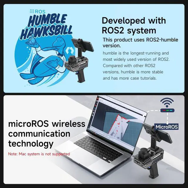
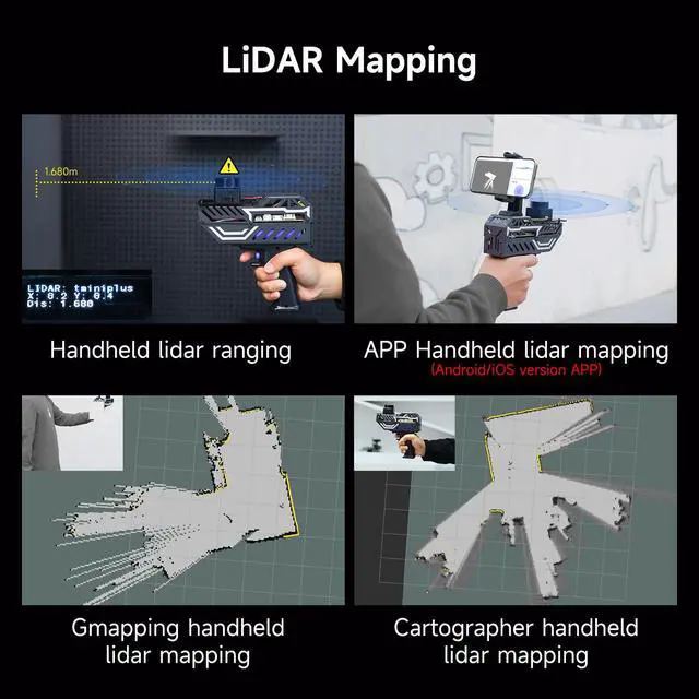
Support IOS and Android APPRun the ROS2 system on the PC virtual machine to realize mapping,and cleverly transfer the mapping data to the APP mobile phone through the APP,so that the Palmslam handheld can view the lidar mapping in real time and explore and scan the unscanned areas.
Complete SDK tutorial and support ROS2Provides compatible handheld mapping, five lidars support ROS2/ROS1, Linux and other document SDK development packages,support ROS and ROS2 operating systems, open Python source code,and provide relevant video tutorials to help customers develop and integrate smoothly across different operating systems and architectures.
Learn more about the Detailed Specifications
Additional Information
First Listed on Newegg
May 15, 2026
There are no reviews yet.
Do you own this product?
Warranty & Returns
Warranty, Returns, And Additional Information
Warranty
Please contact the Seller directly for warranty information. Warranty information may also be found on the Manufacturer's website.
, Cybenetics PLATINUM, Smallest 125mm ATX PSU, Patent Super Connector, Full Modular, SF-1200F14SP")
, FDB Fan, SF-1000F14XP, Black")
 TM8FFE004T0C129")
 M.2 2280 1TB PCIe 4.0 x4 with NVMe 1.4 TLC Internal Solid State Drive (SSD) TM8FFH001T0C128")